Hiking best dates are coming. The nice weather invites hikers from all around the world to practice this sport before the summer arrives. If you use Google Maps you can make the most out of the keys of the app to find your route and practice hiking without getting lost.
It doesn’t matter if you hike on mountains or field sceneries, Google Maps can guide you easily through every spot. Hiking can be a risky activity if you don’t know the zone, but Google Maps is your best aid. The app shows you a complete map with hiking routes as well as other notifications and tools. Even though you have other alternatives, Google Maps updates make it a great solution for hiking trips and you can use it directly from your phone.
Hiking options in Google Maps
The following features of Google Maps are extremely useful for hiking followers. Don’t forget to enable them before starting your routine. They will help you to reach your destination safe and sound as well as fully enjoy the environment.
Forest fires alert
One of the latest Google Maps updates is the forest fires alarm. In times where forest fires are more common, hiking lovers are exposed to these dangerous situations. Because of it, Google Maps introduces forest fires alarms to be prepared when you go around certain routes.
If you want to know if there’s a forest fire nearby you just need to press the layers icon on maps. Select the fire icon and Google Maps will send you news about your surroundings. The app analyzes different sources before giving you the ok to go for a hiking route.
Satellite view
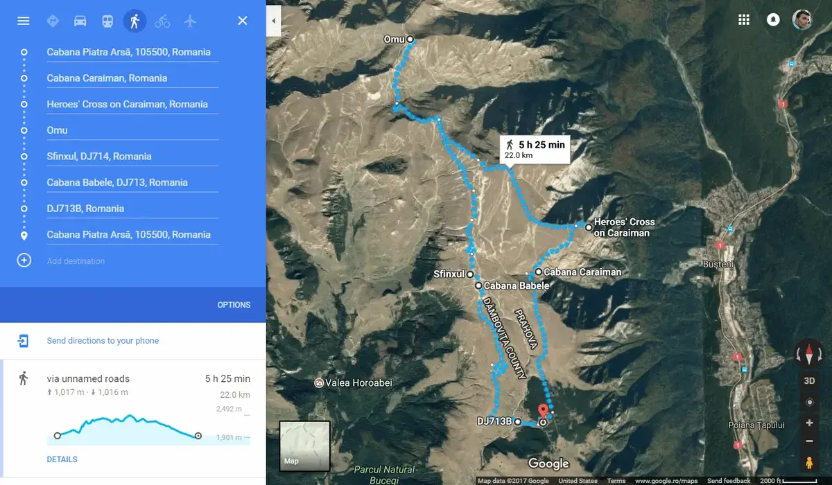
Another great feature of Google Maps for hiking practitioners is the satellite view. It allows you to watch the roads and details of the map in an easy and quick glance. You can zoom in for the points of interest and trace your own route. It’s very difficult to get lost if you use Google Maps properly.
- Open Google Maps on your phone.
- Select the layers icon.
- Click on Satellite view.
Select key points along the road
In case you have started a new hiking route and you don’t know it very well, you can post key points in your map. They will help you to keep track of your own way and follow it again in the future. To create a key point you only need to press on any point of the app and select the Add tab feature. Name it as you will and you can make your own remarks along the road.
Improve location accuracy
When hiking, Google Maps requires a good GPS functionality. It’s normal for the GPS to fail when there’s no connection but you can improve the location accuracy through mobile networks. They work together with the GPS sensors to give you more accuracy. To activate the feature follow these instructions:
- Open Google Maps.
- Press your profile icon.
- Enter app Settings.
- Press on Location settings.
- Select Google Location Accuracy.
- Mark the box to improve GPS location.
Save your favorite spots for hiking in Google Maps
If you want to make a route again along someone but you are afraid of not remembering it, you can create a list of your favorite spots. You can even save your routes to make them again.
- Save the route in Google Maps.
- Choose the list.
- Make a stick note with the most relevant details.
You can also save it from the list menu and press in I want to go or create a new recommendation. Just press the Add button to include it in your list.
Do you have any questions or problems related to the topic of the article? We want to help you.
Leave a comment with your problem or question. We read and respond to all comments, although sometimes it may take a while due to the volume we receive. Additionally, if your question inspires the writing of an article, we will notify you by email when we publish it.
*We moderate comments to avoid spam.
Thank you for enrich our community with your participation!