There are currently 23 fires in Spain in Situation 2. This was confirmed by Civil Defense with the focus on Galicia, Castilla y León and Extremadura. However, there are tens minor fires around the country. One of the most virulent fires in Spain according to the NASA online map is in Jarilla (Cáceres) and it has already destroyed 4.800 hectares.
Using Google Maps you can follow Spain fires in real time thanks to NASA technology. It’s a new tool to improve security and help people avoid damages to certain extents.
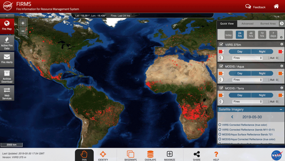
NASA online map to track Spain fires in real time
The National Aeronautics and Space Administration (NASA) offers a tool to eliminate communication problems regarding Spain fires in real time. Thanks to the NASA online map Civil Defense, firefighters and other staff can work better to extinguish the flames and evacuate towns.
NASA uses a renowned technology called Fire Information for Resource Management System (FIRMS). It’s a tool that shows active fires data using several measure devices through the satellites S-NPP, NOAA 20 and NOAA 21. This new NASA map is completely interactive and the users can move around all the plant by dragging the screen around or inputting specific coordinates.
FIRMS recompiles data from different instruments on board the satellites. Using the NASA map you can find information from the Moderate Resolution Imaging Spectroradiometer (MODIS) and Visible Infrared Imaging Radiometer Suite (VIIRS) present on the satellites.
Spain fires information by dates, last 24 hours and 7 previous days
At the moment, the map information is not completely in real time for Spain. The fires status is available within a 3 hours range after the satellite observation. Only United States and Canada are presented in real time simultaneously right now.
Using the new NASA tool you can track Spain fires as well as hot spots near the flames. The user can learn the status of every zone during the last 24 hours or 7 days prior with the Timeline bar on the bottom menu.
There’s another useful feature called Location where you can locate the exact fire spot and learn which towns or roads are nearby. The Measure tool allows to show the affected zone of each fire and the hot spots where you should be careful.
Finally, FIRM includes customization features like the possibility of adding detailed information about towns and roads nearby to fires. You can customize this option using the Layers menu and activating Border – Roads Detailed.
Thanks to the collaboration between NASA and Spain authorities, it’s possible to use new technology to help citizens during fire catastrophes. Spain government and NASA scientists share information and make use of the latest technology improvements. In order to show the latest news regarding fires all around the country.
In the near future, NASA will include real time updates of fires around Spain territory. The goal is to have a special coverage all around the world. A way to learn in real time which zones are affected by fires. This way reducing avoid human losses and damages.
Do you have any questions or problems related to the topic of the article? We want to help you.
Leave a comment with your problem or question. We read and respond to all comments, although sometimes it may take a while due to the volume we receive. Additionally, if your question inspires the writing of an article, we will notify you by email when we publish it.
*We moderate comments to avoid spam.
Thank you for enrich our community with your participation!